Arizona is a state designed for driving. The landscape shifts so dramatically between regions that a single day’s drive can take you from saguaro-studded Sonoran desert to pine forests at 7,000 feet, through ancient river canyons, past painted badlands, and beneath the towering red rock spires that make Arizona instantly recognisable from any photograph.
1. Red Rock Scenic Byway (Highway 179)
Distance: 7.5 miles | Best time: Year-round (sunrise/sunset for best light)
America’s highest-rated scenic drive may also be its shortest. The drive between the Village of Oak Creek and Sedona passes directly beneath towering red sandstone formations — Bell Rock, Courthouse Butte, and Cathedral Rock — that glow crimson in the warm Arizona light. With over 1.7 million Instagram mentions, it’s the most photographed scenic byway in the country. A Red Rock Pass ($5/day) is required for trailhead parking. Read our full guide to the Red Rock Scenic Byway for detailed stop information.
2. Apache Trail (Highway 88)
Distance: 40 miles | Best time: October–April
Theodore Roosevelt called this “the most awe-inspiring and most sublimely beautiful panorama nature ever created.” The partially unpaved road east of Phoenix winds through the Superstition Mountains past three reservoirs, through narrow canyon walls, and to the dramatic Roosevelt Dam. The unpaved section is rough and not recommended for low-clearance vehicles, but the paved portion from Apache Junction to Tortilla Flat (a quirky tourist stop with a population of 6) is accessible to all vehicles and plenty scenic on its own.
3. Kaibab Plateau — North Rim Scenic Drive (Highway 67)
Distance: 44 miles | Best time: May–October (road closes in winter)
Most Grand Canyon visitors go to the South Rim, which means the North Rim drive is quieter, cooler, and arguably more beautiful. Highway 67 climbs through ponderosa pine and aspen forest to the rim at 8,200 feet — over 1,000 feet higher than the South Rim. The North Rim receives a fraction of the South Rim’s visitors, and the views are just as spectacular. The road closes from first snow (usually November) through mid-May.
4. Historic Route 66 — Seligman to Kingman
Distance: 85 miles | Best time: Year-round
The longest remaining uninterrupted stretch of original Route 66 pavement. Seligman is considered the birthplace of the Route 66 preservation movement, and the town’s kitschy shops, vintage signs, and classic Americana charm are genuine rather than manufactured. Hackberry General Store is a perfectly preserved 1930s gas station and trading post. The town of Kingman has an excellent Route 66 museum. This is the section of Arizona’s Route 66 that inspired the fictional town of Radiator Springs in the Pixar film Cars.
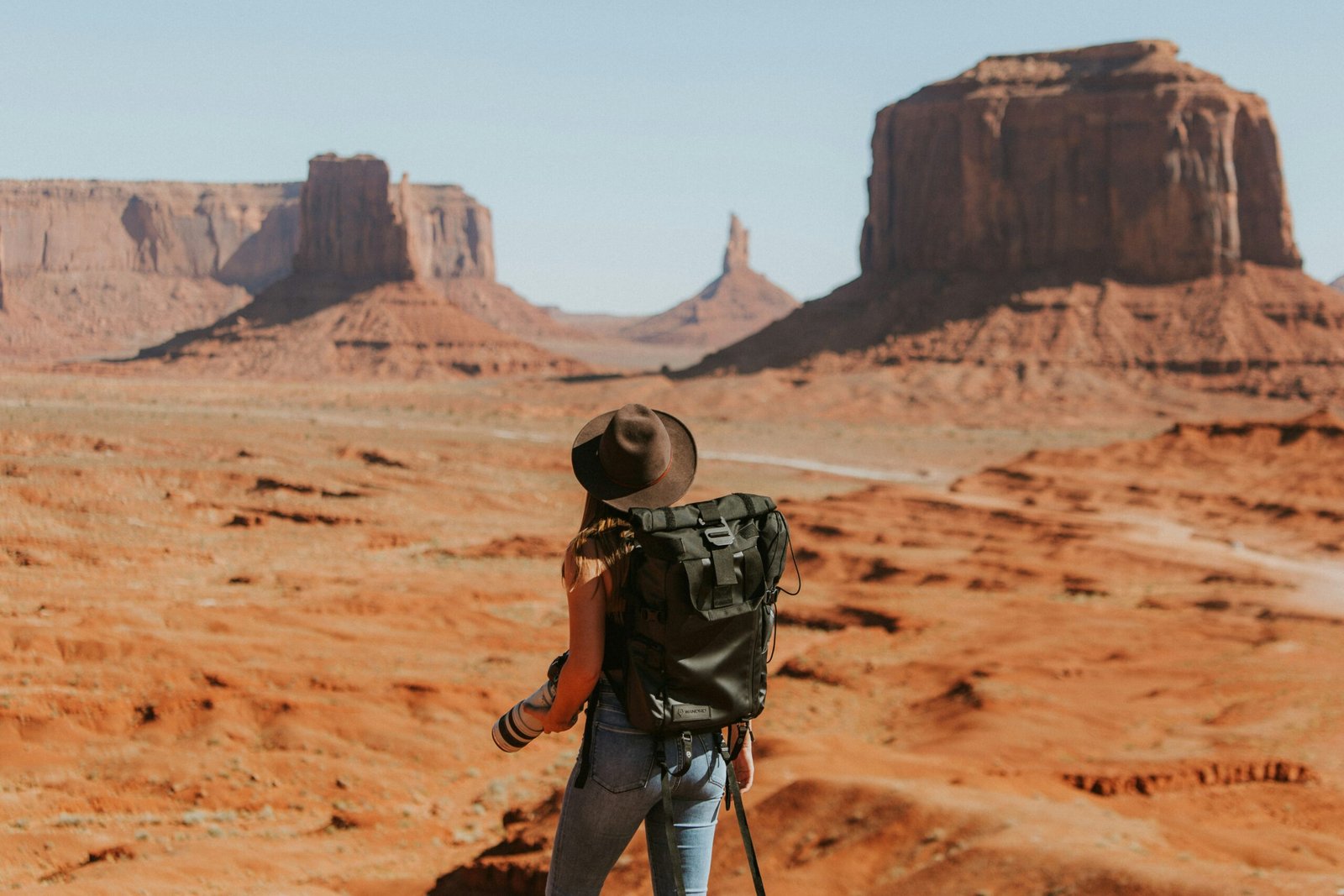
5. Monument Valley Scenic Drive
Distance: 17-mile loop | Best time: Year-round
Technically within the Navajo Nation rather than a state road, the Valley Drive loops through the iconic buttes and mesas that have appeared in countless western films and photographs. The red sandstone formations — Mittens, Merrick Butte, Totem Pole — rise dramatically from the flat desert floor. The road is unpaved and bumpy but passable for most vehicles in dry conditions. Entry fee: $8 per person. Guided Navajo tours access areas closed to self-drive visitors and provide cultural context that enriches the experience significantly.
6. Coronado Trail Scenic Byway (US 191)
Distance: 123 miles | Best time: April–November
One of the least-driven scenic byways in America — and one of the most dramatic. The road contains over 460 curves between Clifton and Springerville, climbing from 3,500 feet in the Sonoran desert to 9,000 feet in alpine forest. The transition between ecological zones is stunning, passing through five distinct vegetation communities. Named for the route taken by Spanish explorer Francisco Vásquez de Coronado in 1540. Allow a full day — the curves make the drive slow but mesmerising.
7. Vermilion Cliffs Scenic Drive (Highway 89A)
Distance: 65 miles | Best time: Year-round
Connecting Flagstaff to the Utah border via Marble Canyon, this drive crosses the Colorado Plateau through some of Arizona’s most remote and colourful terrain. The Vermilion Cliffs glow red and orange in the morning light — a 3,000-foot wall of sandstone that stretches for miles. The Navajo Bridge over Marble Canyon is a dramatic crossing 470 feet above the Colorado River. California condors are frequently spotted soaring near the bridge — binoculars are worthwhile.
8. Mount Lemmon Scenic Byway (Sky Island Scenic Byway)
Distance: 27 miles | Best time: Year-round
Rising from the desert floor outside Tucson to the 9,157-foot summit of Mount Lemmon, this drive climbs through the biological equivalent of driving from Mexico to Canada in under an hour. You start in cactus and creosote bush, pass through oak woodland, enter pine forest, and arrive in a spruce-fir zone at the summit where summer temperatures are 30 degrees cooler than the city below. The village of Summerhaven at the top has a pizza restaurant and small shops. In winter, the summit has enough snow for a small ski area — the southernmost ski resort in the US.
Summer heat warning: Arizona’s desert scenic drives can be genuinely dangerous in summer. Temperatures regularly exceed 110°F (43°C) between June and September. Carry at least one gallon of water per person, never leave children or pets in vehicles, and avoid hiking during midday heat. If your car overheats, pull over immediately, turn off the AC, and run the heater to draw heat away from the engine. October through April is the ideal season for desert driving.
Frequently asked questions


Leave a Reply