Montana earns its “Big Sky Country” nickname the moment you hit the open road. With more land than people, the state offers some of America’s most dramatic and least crowded scenic drives — from glacier-carved mountain passes to vast prairie horizons that stretch so far they curve with the earth.
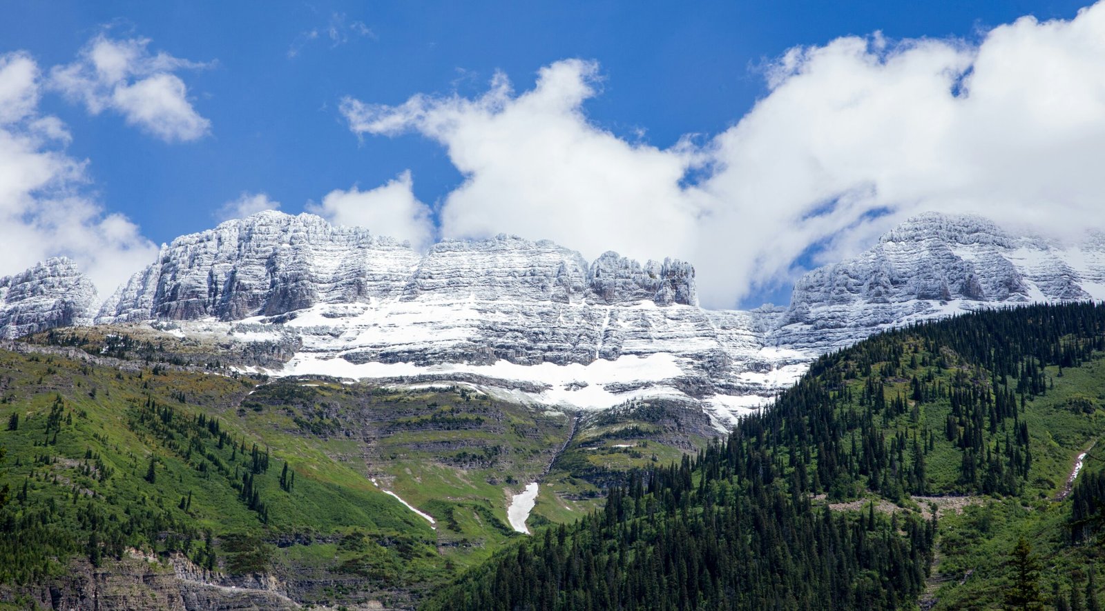
1. Going-to-the-Sun Road — Glacier National Park
Distance: 50 miles | Highest point: 6,646 ft (Logan Pass) | Season: June–October
America’s most famous mountain road and arguably the most beautiful 50 miles of pavement in the country. The road clings to sheer cliff faces above glacial valleys, crosses the Continental Divide at Logan Pass, and passes waterfalls that cascade directly onto the road surface. Mountain goats are frequently spotted at Logan Pass. Vehicle length restrictions apply — no vehicles longer than 21 feet or wider than 8 feet. A reservation is required during peak summer months. The road typically opens fully by mid-June and closes after the first major snowfall in October.
2. Beartooth Highway (US 212)
Distance: 68 miles | Highest point: 10,947 ft | Season: Late May–October
Charles Kuralt called it “the most beautiful drive in America,” and he had a point. The Beartooth Highway climbs from the lush forests of Red Lodge to a treeless alpine plateau above 10,000 feet where snow patches persist through July. The switchbacks on the ascent are dramatic — twenty hairpin turns climbing 5,000 feet in under 20 miles. At the summit, you’re surrounded by over a dozen peaks exceeding 12,000 feet. The road connects to the northeast entrance of Yellowstone, making it the most scenic gateway into the park.
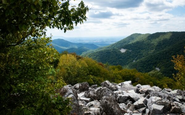
3. Highway 2 — Glacier Park’s Southern Border
Distance: 57 miles (East Glacier to West Glacier) | Season: Year-round
While Going-to-the-Sun Road gets the fame, Highway 2 along Glacier’s southern boundary is open year-round and offers equally stunning views of the park’s southern peaks. The road follows the Middle Fork of the Flathead River through dense forest with mountain views in every direction. Marias Pass at 5,213 feet is the lowest crossing of the Continental Divide in the northern US. In winter, the contrast of snow-covered peaks against dark evergreen forests is extraordinary.
4. Chief Joseph Scenic Byway (Highway 296)
Distance: 47 miles | Season: May–November
Named for the Nez Perce leader who led his people through this corridor in 1877, this highway connects Cody, Wyoming to the Beartooth Highway through some of the most remote terrain in the northern Rockies. Dead Indian Pass offers sweeping views of the Absaroka Range. The Sunlight Basin section winds through a dramatic canyon with towering rock walls. Far fewer tourists than Beartooth, making it feel like your own private mountain road.
5. Flathead Lake Loop
Distance: 85-mile loop | Season: Year-round
A circuit around the largest natural freshwater lake west of the Mississippi. The east shore road (Highway 35) hugs the waterline with mountain views reflected in crystal-clear water. The west shore (Highway 93) passes cherry orchards that bloom spectacularly in late May. Flathead Lake is so clear you can see the bottom at 30 feet. The town of Bigfork on the northeast corner is a charming arts community worth a stop. Wild Horse Island, visible from several viewpoints, is home to bighorn sheep and wild horses accessible by boat.
6. Pioneer Mountains Scenic Byway
Distance: 44 miles | Season: June–October
One of Montana’s best-kept secrets. This gravel-and-paved road loops through the Pioneer Mountains south of Anaconda, passing ghost towns, alpine lakes, and wildflower meadows. Crystal Park, where visitors can dig for quartz crystals, is a unique stop along the route. Elkhorn Hot Springs at the southern end of the loop has rustic cabins and a natural hot pool fed by geothermal springs. The unpaved sections are well-maintained but not recommended after heavy rain.
7. Big Hole Valley (Highway 278)
Distance: 60 miles | Season: Year-round
Known as the “Land of 10,000 Haystacks,” the Big Hole Valley is one of the last places in America where ranchers still use traditional beaver-slide hay stackers. The road through the valley is flanked by the Bitterroot Range and Pioneer Mountains with irrigated meadows stretching between them. The Big Hole National Battlefield preserves the site of an 1877 conflict between the US Army and the Nez Perce. Jackson Hot Springs Lodge offers a natural hot pool open to the public year-round.
8. Highway 200 — Blackfoot Valley
Distance: 90 miles (Missoula to Lincoln) | Season: Year-round
This is the Montana that Norman Maclean wrote about in “A River Runs Through It.” The highway follows the Blackfoot River through a pastoral valley of cattle ranches, cottonwood-lined riverbanks, and forested foothills. The river itself is one of Montana’s finest for fly fishing. Garnet Ghost Town, accessible from a side road, is one of the best-preserved ghost towns in the state — over 30 buildings remain standing from the 1890s gold rush.
9. Missouri Breaks Back Country Byway
Distance: 73 miles | Season: May–October (dry conditions only)
A rugged, remote drive through the Upper Missouri River Breaks National Monument. This is Lewis and Clark country — the landscape has changed remarkably little since the Corps of Discovery passed through in 1805. White sandstone cliffs, hoodoo formations, and vast prairie vistas dominate the scenery. The road is unpaved and requires high clearance. Cell service is nonexistent. Bring extra water, a spare tire, and a full tank of fuel. For experienced adventurers only, but the solitude and raw beauty are unmatched.
10. Highway 89 — White Sulphur Springs to Glacier
Distance: 200+ miles | Season: Year-round
A full-day drive that takes you through the geographic heart of Montana — from the Castle Mountains through the Little Belt Mountains, across the Great Plains near Great Falls, and into the Rocky Mountain Front where the prairies slam dramatically into the mountains with no foothills as a buffer. The stretch from Choteau to Browning along the Rocky Mountain Front is one of the most dramatic transitions in American geography. This is grizzly bear country — sightings from the road are not uncommon.
Montana driving tip: Distances between services are enormous. It’s common to drive 80-100 miles between gas stations on rural highways. Fill up whenever you can, carry water, and let someone know your route if you’re heading into remote areas. Montana has no speed limit on some rural interstates — posted as “reasonable and prudent” — but secondary roads are typically 70 mph daytime.
Frequently asked questions
Leave a Reply