Oregon is a state of dramatic contrasts — rainforest-thick coastline in the west, high desert badlands in the east, volcanic peaks punctuating the spine of the Cascades, and river gorges cutting through it all. No other state in the Pacific Northwest packs this much scenic variety into its road network.
1. Oregon Coast Highway (US 101)
Distance: 363 miles | Season: Year-round
The full length of Oregon’s coastline in one continuous drive. Unlike California’s PCH, Oregon’s coast is entirely public — no private beaches blocking access. Cannon Beach and its iconic Haystack Rock are the most photographed stops. The Samuel H. Boardman State Scenic Corridor in the south is a 12-mile stretch of sea stacks, natural bridges, and hidden coves that rivals anything on the California coast. Cape Perpetua offers a viewpoint 800 feet above the ocean. Thor’s Well, a natural sinkhole in the rock shelf, creates dramatic ocean surges at high tide.
2. Historic Columbia River Highway
Distance: 75 miles | Season: Year-round (some sections close in winter)
America’s first planned scenic highway, designed in 1913 specifically for the pleasure of driving. The road winds through the Columbia River Gorge past Multnomah Falls — the tallest waterfall in Oregon at 620 feet — and dozens of smaller cascades accessible from short trails. Crown Point’s Vista House perches 733 feet above the river with 30-mile views in both directions. The engineering is a marvel — stone-arch bridges, viaducts, and tunnels blending seamlessly with the landscape.
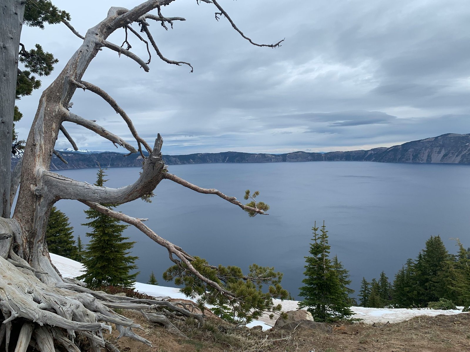
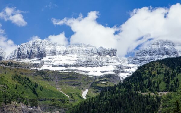
3. Crater Lake Rim Drive
Distance: 33-mile loop | Highest point: 7,863 ft | Season: July–October
A complete circuit around the deepest lake in America — 1,943 feet of impossibly blue water filling a collapsed volcano. The rim drive has over 30 overlooks, each offering a different perspective on the caldera. Wizard Island, a volcanic cinder cone rising from the lake, is accessible by boat tour in summer. The drive is short in distance but takes two to three hours with photo stops because you’ll want to stop at every viewpoint. Snow closes the full loop from October through late June, though the south entrance and a partial rim drive open earlier.
4. Cascade Lakes Scenic Byway
Distance: 66 miles | Season: June–October
Starting from Bend, this route loops through the heart of the Oregon Cascades past a chain of pristine alpine lakes. Sparks Lake reflects the jagged peaks of South Sister and Broken Top on calm mornings — arrive before 9 AM for mirror-flat water. Todd Lake and Devils Lake are smaller but equally photogenic. Mount Bachelor ski resort offers a summer chairlift to 9,065 feet for panoramic views of the entire Cascade Range. The road is popular with cyclists — share the road and give them space.
5. McKenzie Pass-Santiam Pass Scenic Byway
Distance: 82 miles | Season: June–October
The most geologically dramatic drive in Oregon. The McKenzie Pass section crosses a massive lava field — miles of black basalt stretching in every direction, punctuated by snow-capped volcanic peaks. The Dee Wright Observatory at the summit is built entirely from lava rock and has viewing windows framing each major Cascade peak. The contrast between the barren lava fields and the lush forest on either side is surreal. Proxy Falls, a short detour off the highway, is a 200-foot waterfall cascading over a mossy cliff into a pool that has no visible outlet — the water drains through porous lava underground.
6. Hells Canyon Scenic Byway
Distance: 218 miles | Season: Year-round (some sections seasonal)
North America’s deepest river gorge — deeper than the Grand Canyon at 7,993 feet from rim to river. The drive from Baker City through Halfway and along the Snake River reveals layer after layer of geological history. The Hells Canyon Overlook on Forest Road 3965 provides a jaw-dropping view straight down into the gorge. Jet boat tours run from the small town of Hells Canyon Dam. This is remote Oregon at its most raw — expect limited services and no cell signal for long stretches.
7. Painted Hills and John Day Fossil Beds
Distance: 120 miles (Mitchell to John Day) | Season: Year-round
Oregon’s answer to the American Southwest. The Painted Hills are striped mounds of red, gold, and black volcanic ash that look almost artificial in their vivid coloring. The colours are most intense after rain when the clay absorbs moisture. The nearby John Day Fossil Beds contain some of the most complete fossil records of the Cenozoic Era anywhere in the world. The Thomas Condon Paleontology Center has free admission and excellent exhibits. This area receives a fraction of the visitors that western Oregon’s coast gets, despite being equally photogenic.
8. Rogue-Umpqua Scenic Byway
Distance: 172 miles | Season: Year-round
Following the North Umpqua and Rogue Rivers through old-growth Douglas fir forest, this drive connects Roseburg to Crater Lake through some of Oregon’s most pristine wilderness. Toketee Falls is a two-tiered waterfall plunging over columnar basalt into a turquoise pool — it’s a half-mile hike from the road. The river sections are world-class for steelhead and salmon fishing. Umpqua Hot Springs, perched on a hillside above the river, is one of Oregon’s best natural hot springs — free and open 24 hours.
9. Steens Mountain Loop
Distance: 66-mile loop | Highest point: 9,738 ft | Season: July–October
Oregon’s most remote scenic drive climbs a fault-block mountain in the high desert to nearly 10,000 feet. The east face drops off in a sheer 5,000-foot escarpment — one of the most dramatic cliff edges you can drive to in the western US. Kiger Gorge and Little Blitzen Gorge are U-shaped glacial valleys visible from the rim road. Wild mustangs roam the surrounding Steens Mountain Wilderness. The road is unpaved above 6,000 feet and requires high clearance. There are no services, no cell signal, and no guardrails at the summit viewpoints. Bring everything you need.
10. Elkhorn Drive Scenic Byway
Distance: 106 miles | Season: June–October
A loop through the Elkhorn Mountains in northeastern Oregon, passing the ghost towns of the Blue Mountain gold rush. Sumpter is the most accessible, with a historic gold dredge you can tour and a narrow-gauge steam railway. Anthony Lakes ski area at the byway’s summit offers alpine hiking in summer with views across the Blue Mountains. The mining history is visible everywhere — abandoned stamp mills, tailings piles, and collapsed cabins dot the roadsides. Bring a gold pan if you want to try your luck in the streams.
Oregon road trip tip: Oregon doesn’t allow self-service gasoline — an attendant pumps your fuel at every gas station (one of only two states with this law). Don’t get out of your car at the pump. Tipping is not expected but appreciated. Also note that Oregon has no sales tax, making it a great state for gear purchases along your route.
Frequently asked questions
Leave a Reply