Virginia is where American scenic driving was born. Skyline Drive opened in 1939 and set the template for every mountain road that followed. Today, the state offers an embarrassment of riches for drivers — from the Blue Ridge Parkway’s gentle curves to Civil War battlefields, tidewater marshes, and Appalachian hollows where time seems to have slowed down.
1. Skyline Drive — Shenandoah National Park
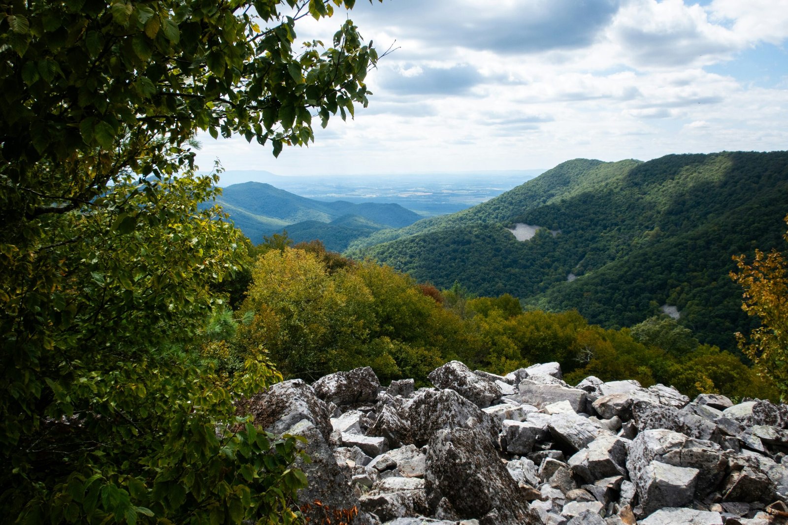
Distance: 105 miles | Highest point: 3,680 ft | Season: Year-round (some sections close in winter)
Running the entire length of Shenandoah National Park along the crest of the Blue Ridge Mountains, Skyline Drive has 75 overlooks in 105 miles — roughly one every 1.4 miles. On clear days, views extend 65 miles into the Shenandoah Valley to the west and the Piedmont to the east. The speed limit is 35 mph, which perfectly matches the road’s purpose: slow down, stop often, breathe deeply. Fall foliage is peak season with reds and oranges coating every hillside. White-tailed deer are so abundant they’re practically guaranteed sightings. A park entry fee of $30 per vehicle applies.
2. Blue Ridge Parkway (Virginia Section)
Distance: 217 miles | Season: Year-round (higher sections may close in winter)
Picking up where Skyline Drive ends at Rockfish Gap, the Blue Ridge Parkway continues south through Virginia’s most scenic mountain country. Milepost 0 to 217 is the Virginia section before the road crosses into North Carolina. Peaks of Otter at milepost 86 has a lodge, restaurant, and the beautiful Abbott Lake reflecting Sharp Top Mountain. The Roanoke area section (mileposts 105-130) offers sweeping views and the iconic Roanoke Star, the world’s largest freestanding illuminated man-made star. No entrance fee — the Parkway is free to drive.
3. George Washington Memorial Parkway
Distance: 25 miles | Season: Year-round
Connecting Mount Vernon to Great Falls Park along the Potomac River, this parkway offers views of Washington DC’s monuments from across the river. The drive is especially stunning during cherry blossom season in late March and early April when the riverbanks bloom pink. Great Falls at the northern end features dramatic rapids where the Potomac drops 76 feet through a series of cascades. One of the few scenic drives accessible from a major metropolitan area.
4. Route 39 — Goshen Pass
Distance: 35 miles | Season: Year-round
A narrow mountain road following the Maury River through a deep gorge in the Alleghany Highlands. The pass is a favourite of Virginia locals but rarely appears in tourist guides. Rock walls rise steeply on both sides of the road, and in spring the river runs fast with whitewater. The road was hand-cut through solid rock in the 1850s and remains narrow enough that two vehicles must slow to pass. Swimming holes along the river are popular in summer — Goshen Pass Natural Area has several accessible from short trails.
5. Virginia Creeper Trail Scenic Drive (US 58)
Distance: 34 miles (Damascus to Whitetop) | Season: Year-round
US 58 parallels the famous Virginia Creeper bicycle trail through some of the most remote mountain country in the state. The road climbs from the charming trail town of Damascus to Whitetop Station at 3,576 feet. Mount Rogers, Virginia’s highest peak at 5,729 feet, is visible from several points along the route. The area is home to wild ponies in the Grayson Highlands — they’re accustomed to people and often approach cars in the parking areas.
6. Colonial Parkway
Distance: 23 miles | Season: Year-round
Connecting Jamestown, Williamsburg, and Yorktown — the three corners of America’s Colonial triangle — this parkway is more about history than mountain scenery. The road follows the York River and passes through tidal marshes, pine forests, and colonial-era landscapes. No commercial signs or modern buildings are visible from the road, preserving the historic atmosphere. The speed limit of 45 mph and prohibition on commercial vehicles make it a peaceful, contemplative drive through the origins of American history.
7. Route 250 — Staunton to the West Virginia Border
Distance: 40 miles | Season: Year-round
Crossing the Alleghany Mountains on one of Virginia’s oldest mountain roads, Route 250 offers a different kind of scenic drive — intimate rather than panoramic. The road climbs through mixed hardwood forest, crosses streams on stone bridges, and passes through tiny mountain communities. The Highland County section west of Staunton is sometimes called “Virginia’s Switzerland” for its rolling highland meadows and pastoral beauty. In March, the Highland Maple Festival draws visitors to watch syrup production at local farms.
8. Route 211 — New Market to Luray
Distance: 25 miles | Season: Year-round
A short but rewarding drive crossing the Massanutten Mountain between the Shenandoah Valley and the Page Valley. The climb through the gap offers views of both valleys from the summit. Luray Caverns at the eastern end is one of the largest and most spectacular cave systems in the eastern US — the stalactite organ alone is worth the visit. New Market Battlefield at the western end preserves the site of a Civil War engagement where teenage cadets from VMI were called into combat.
9. Back of the Dragon (Route 16)
Distance: 32 miles | Season: Year-round
Virginia’s answer to North Carolina’s Tail of the Dragon. This winding mountain road between Marion and Tazewell has over 400 curves in 32 miles — a favourite of motorcycle riders and driving enthusiasts. The road climbs through dense forest with occasional openings revealing valley views. Named by local riders, the road has been paved smoothly and is well-maintained. Drive it on a weekday to avoid motorcycle group traffic. Multiple pullouts allow slower vehicles to let faster traffic pass.
10. Route 33 — Harrisonburg to the West Virginia Border
Distance: 28 miles | Season: Year-round
Crossing the Shenandoah Mountain through the George Washington National Forest, this route climbs to over 3,200 feet with views extending across wave after wave of Appalachian ridges. The road is wide and well-maintained, making it accessible to all vehicles. The western descent into the Dry River Valley is particularly scenic, with open meadows flanked by forested ridges. Switzer Dam, just off the highway, is a peaceful reservoir surrounded by mature forest — a perfect picnic stop.
Virginia driving tip: Fall foliage season (mid-October to early November) is peak time for scenic driving in Virginia. Skyline Drive and the Blue Ridge Parkway are especially popular — visit on weekdays to avoid weekend traffic. The Virginia Tourism website publishes a weekly fall foliage report starting in September with region-by-region colour status.
Frequently asked questions
Leave a Reply